Until the modern era, roads tended to just happen. If enough people went from A to B their footsteps or wheels left a track for others to follow, thus it eventually became a road. As has been seen, their upkeep was a problem because it was not necessarily those who used the roads that had to pay for them. It was thought a more equitable way of recouping the cost of maintaining major routes was by creating turnpikes and exacting tolls from users. It was not a great success, however, people avoided them by either taking to side tracks or the water: the North Walsham to Dilham Canal, for example, built in 1812, was reputedly to avoid tolls, and by the late nineteenth century turnpike trusts had disappeared resulting in many major routes starting to fall into decline, thanks to the coming of the railway.
For most people travel by road was difficult and costly, but once railway networks were established from the mid nineteenth century onwards, not only was moving heavy goods by train quicker and cheaper than by road, but also leisure travel was brought into the reach of the middle and lower sorts, leading to the popularity of The Broads and the development of former fishing villages such as Cromer and Sheringham into holiday resorts.
Roads did not fall into disuse, though, quite the opposite, thanks to the development of the internal combustion engine in the late 19th century. Although early motor car ownership was only for the wealthy enthusiast, the increasing popularity of cycling and continued use of horses made it soon necessary for all road traffic to be controlled for fear of fatal accidents. 1861 saw the first of the Locomotive Acts, followed by further legislation in 1865 and 1878. These, popularly known as the ‘Red Flag Acts,’ required the maximum speed of all vehicles to be 4 mph in the country and 2mph in the city. In1861 vehicles had to be manned by two persons and carry lights but the speed limit was raised to 5 mph in towns and 10 mph in the country. By1896 the speed limit was raised to 14 mph. The final Locomotive Act which was passed in 1898 formalised vehicle registration, maximum vehicle weight over structures such as bridges and the organisation of highway authorities. The formation of County Councils in 1889 meant they took over responsibility for main roads, although Rural District Councils did not become responsible for local roads until 1894.
Locally it was becoming apparent that our roads were no longer fit for purpose – unsurprisingly it was the Horstead cross-roads[i] and Station Road, Coltishall that were the main local hot spots, although it has to be said that the accidents and near misses reported in the press were as much due to driver carelessness as anything else! Driving a tumbril and three horses along the high road between Coltishall and Horstead without reins to guide them; several instances of driving ‘furiously’ at 12 mph; and a steam lorry driven too fast to be able to take the bend by Coltishall railway station were just a few instances.
Horses, being unpredictable, were also often the cause of accidents; a Mr Haggith, driving a pony and cart was overtaken by a gentleman driving a young horse which then took fright at a block of wood by the side of the road. One of the wheels caught Mr Haggith’s cart and both carts were overturned. Fortunately, no-one was badly hurt but the number of accidents along the North Walsham and Rectory Roads caused Michael Falcon, estate manager at Horstead Hall, to write to the press about dangerous corners where it was impossible to see what was coming. ‘It does seem a great pity, that a beginning should not be made with these corners,’ he wrote in 1905, ‘One of them is a bad one onto the main North Walsham Road…’[ii] Further complaints in 1907 to the County Surveyor that, ‘Our roads were never designed for fast motor traffic,’ received the terse reply that there so many such dangerous corners that the County Council could not afford to attend to all of them. Sound familiar?
In recording a 1910 collision between a motor car and a cyclist outside the Recruiting Sergeant the Norfolk News commented that a serious accident to another cyclist, had occurred only one year earlier on the same ‘dangerous corner.’ In neither case were road users deemed to have been at fault, the problem being, ‘the dangerous nature of the corner, neither party being able to see what was coming.’[iii] There were, however many instances of drivers and cyclists proceeding ‘furiously’ at speeds up to 12 mph, which is faster than a trotting horse. Traffic control signals had first appeared in 1868, but the use of standardised road signs to warn of hazards was not introduced until the 1934 Road Traffic Act and the driving test was not made compulsory until 1935.
Of course the major disaster that came to the villages and affected traffic to North Walsham was the great flood of 1912, which swept away the bridge at Coltishall as well as many others, effectively cutting off most of North Norfolk. The local press later reported that the new bridge was to be built of ferro concrete and have a span of 40ft (the previous on was 27ft). Unlike the previous bridge it would have a single span to allow easier passage of the waterway. It was wide enough to allow two cars to pass and was eventually completed 2 years later, but surprisingly, without a footbridge, which was only added in 1937. Crostwick Bridge, built in 1820 to replace the dangerous ford, was far enough south to survive.
The Ministry of Transport was created in 1920 and although road numbering began just before the First World War it was abandoned until after 1919, when the increase in the number of motor cars led to further problems for our roads requiring them to be easily identified. It has been estimated that in 1895 there were between 14 and 15 motor cars in England and Wales, five years later the number had risen to between 700 and 800. In 1930 there were an estimated one million motor vehicles, and in 1967 10 million. According to Government statistics, in 2023 there were 33.58 million cars, 4.73m LGVs, 0.54m HGVs, 0.14m buses and coaches and 0.86m other vehicles on our roads, the majority of which were not designed for that amount of traffic. It is also acknowledged that the more roads that are built, the more the traffic on them increases, requiring more roads.
A study by the RAC Foundation concluded that:
“The private car now plays a central role in the lives of the large majority of households and individuals in Great Britain. Across the population as a whole in 2006 nearly two-thirds of all daily trips were made by car, and around four fifths of domestic mileage was by car; in a typical week 80% of the population travelled at least once by car.”
Nearly twenty years on, despite the rise in the numbers working from home after Covid-19, it is fair to say nothing much has changed, except for the worse as the residents of Coltishall and Horstead know only too well. Statistics from the Speed Awareness Monitors have shown a continued steady rise in the amount of traffic along the B1150 as more and more of North Norfolk is developed. Statistics from the DoT and published by Crashmap show that in the years between 2013 and 2022 there was a total of 108 reported road traffic accidents on the North Walsham Road, of which 5 were fatal and 22 considered serious. At what point will it be deemed to be too much?[iv]
[i] This was before the road was altered and the mini roundabout constructed.
ii Eastern Daily Press, 26 January 1905
[iii] Lowestoft Journal 11 September 1909
Sources
Online:
Traffic statistics: https://www.gov.uk/government/statistics/road-traffic-estimates-in-great-britain-2022/road-traffic-estimates-in-great-britain-2022-traffic-in-great-britain-by-vehicle-type
Newspaper reports: www.britishnewspaperarchive.co.uk
Accident statistics: www.crashmap.co.uk
Other:
Lucas, K & Jones, P. The Car in British Society. RAC Foundation. London. 2009.
Taylor, C. Roads and Tracks of Britain. Dent. London. 1979.
Illustrations:
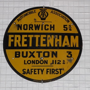
Fig 1: Pre 1934 AA Sign. Most road signs were erected by cycling or motoring clubs before standardisation in the 1930s. Photo: The Author/Gressenhall Museum
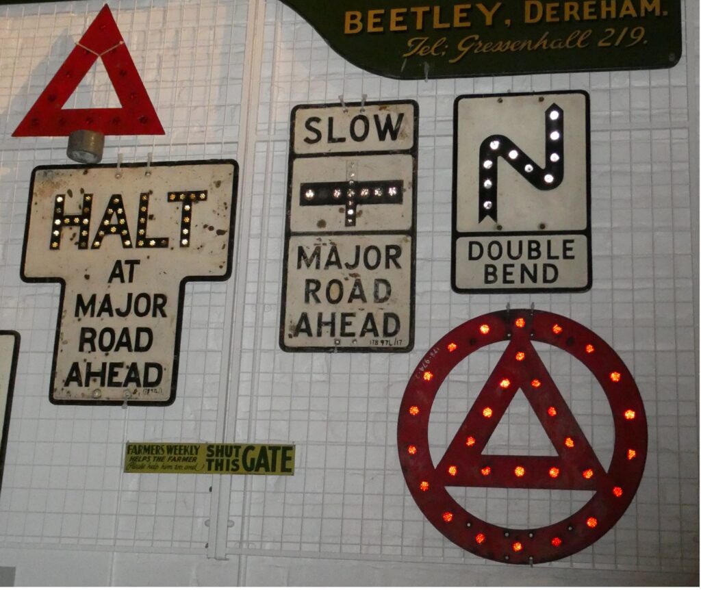
Fig 2: Pre 1968 Traffic Signs at Gressenhall Museum. Photo The Author
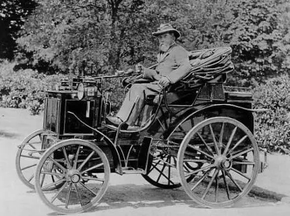
Fig 3: The Hon. Evelyn Ellis in his 1895 Panhard et Levassor motor car – reputed to be the first motor car in Britain, but a French Import.
Photo © National Motor Museum, Beaulieu.
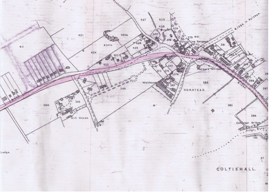
Fig 4: NCC 1953 plan for the alteration of the N Walsham Road in Horstead. The new road is shown in pink, Source: The Author.
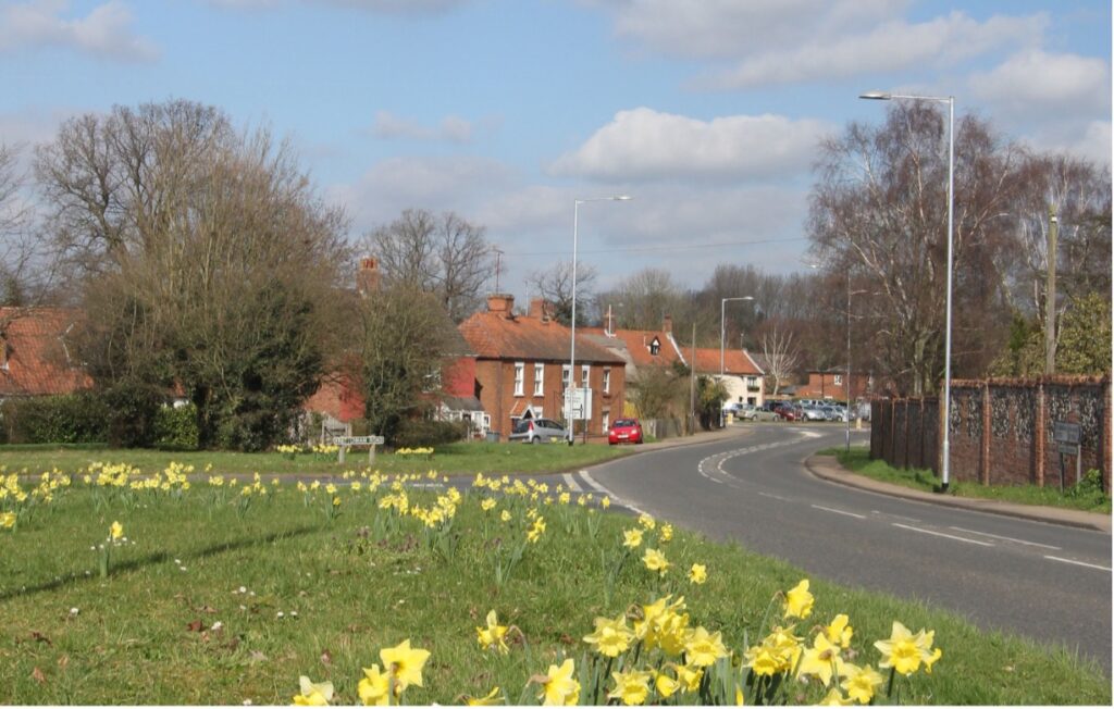
Fig 5: North Walsham Road looking down the hill with the Recruiting Sergeant in the background. Note the houses in the foreground which follow the original line of the road. Photo: The Author.